













面向国土空间规划实施评估的双路径土地利用变化模拟方法
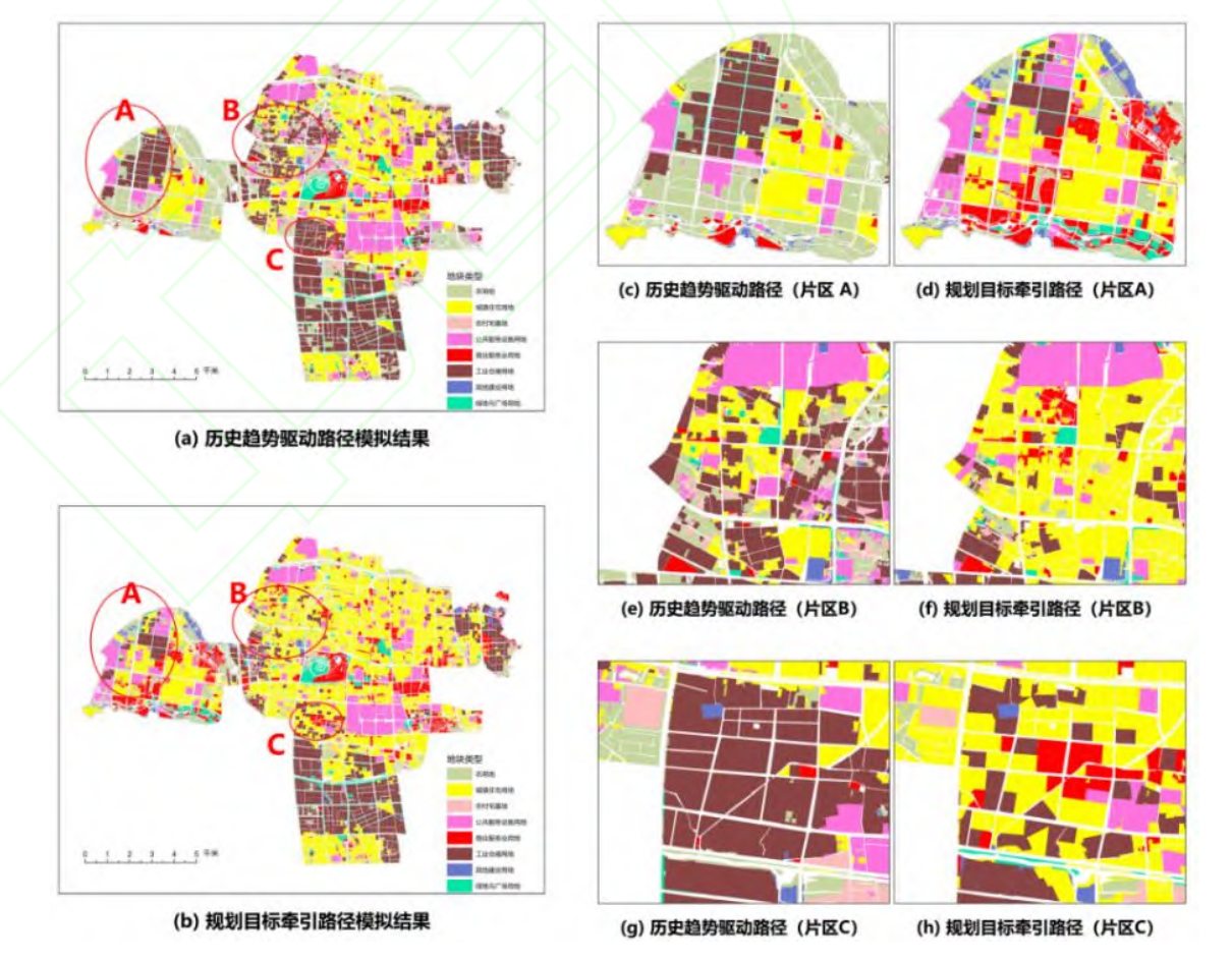
规划实施评估和重点区域调控是国土空间规划进入实施管理阶段后的重要需求。现有土地利用变化模拟多侧重单一路径下的格局预测,难以在统一条件下辨析历史惯性与规划目标导向的差异。为此,提出一种融合历史变化基线与规划目标导向的双路径土地利用变化模拟方法。基于 2019—2024 年土地利用、空间驱动与约束及 2035 年国土空间规划数据,采用马尔可夫链模型与矢量元胞自动机模型构建历史趋势驱动路径;以现状与规划目标的差额为数量约束,构建规划目标牵引路径;进而对双路径结果进行数量结构、空间配置和规划偏离对比与叠置诊断。以常州市武进区中心城区为研究区,结果表明:模型回测中,数量预测的 L1 精度为 0.98,空间模拟的总体精度、Kappa 系数和优值因子分别为 0.92、0.90 和 0.26;双路径差异主要集中于农用地、城镇住宅用地、工业仓储用地和商业服务业用地,并在外围发展区、既有开发区及工业连续带边缘集聚;双路径协调区、历史惯性偏离区、规划实施难点区和规划调整不稳定区分别占研究区的 48.21%、18.90%、27.12%和 5.77%。
Simulating Urban Economic Development via S-Curve & CA
Urban economic forecasting is crucial for the formulation of a macroeconomic development strategy for a region toward harmonious socio-economic and ecological progress. Cellular Automata (CA) enables fine-grained urban economic modeling, but its conventional discrete-state structure performs poorly when handling continuous economic variables like GDP density, and furthermore often lacks the ability to integrate with general economic growth patterns. These shortcomings ultimately compromise the simulation accuracy of urban economic dynamics.

Deep generative model for human mobility behavior
Understanding and modeling human mobility is central to challenges in transport planning, sustainable urban design, and public health. Despite decades of effort, simulating individual mobility remains challenging because of its complex, context-dependent, and exploratory nature. Here, building on the activity-based view of daily mobility, we propose MobilityGen, a diffusion-based generative framework for simulating multi-attribute activity-travel sequences over days to weeks at large spatial scales. By linking behavioral attributes with environmental context, MobilityGen reproduces key patterns such as scaling laws for location visits, activity time allocation, and the coupled evolution of travel mode and destination choices. It reflects spatio-temporal variability and generates diverse and plausible mobility patterns consistent with the built environment. Beyond standard validation, MobilityGen enables analyses that have been difficult with earlier models, including how access to urban space varies across travel modes and how co-presence dynamics shape social exposure and segregation. Together, these results support an integrated, data-driven basis for fine-grained studies of human mobility behavior and its societal implications.
The Scaling Bottleneck of Human Mobility Modeling
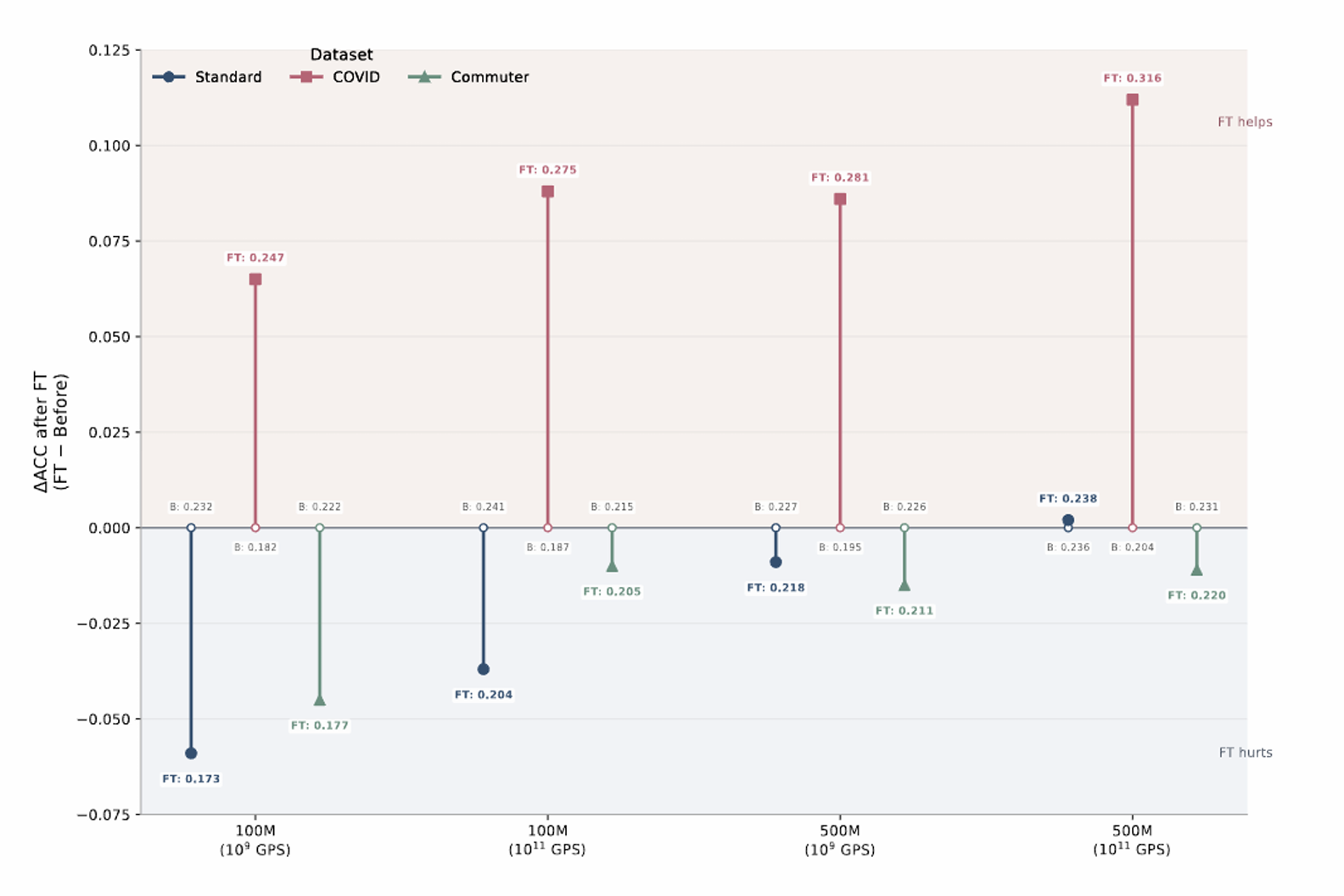
Although scaling—training larger models on larger datasets withmore compute—has proven effective for gaining performance andgeneralization across many data modalities, a comparable trendhas not yet emerged in human mobility modeling. Existing workin human mobility modeling has largely remained limited to rela-tively small models (<500M parameters) and modest data volumes(<1B samples), leaving it unclear whether, and how, scaling benefitsthis domain. This gap has limited progress toward human mobilityfoundation models for broad societal applications. In this work, weconstruct a large-scale real-world human mobility dataset compris-ing trillions of timestamped positioning records from millions ofindividuals, and take a first step toward scaling human mobilitymodeling. We first investigate whether human mobility modelsexhibit scaling behavior similar to that observed in other domains.Extensive experiments at data scales up to 1011 samples reveal anunexpected failure of conventional scaling in human mobility mod-eling. We then explore the source of this scaling failure and trace itto sample-quality issues inherent in the prevailing place-visitation(PV) modeling paradigm. Finally, we propose spatial-interactionbehavior (SIB) modeling, a new paradigm designed to overcomethis bottleneck and enable effective scaling in human mobility mod-eling. We show that SIB-based scaling recovers power-law scalingbehavior and yields models that can be directly adapted to diversedownstream tasks. These findings identify both a key obstacle toscaling mobility models and a practical route toward scalable hu-man mobility foundation models. Code and supplemental materials:https://fukamaru.github.io/human-mobility-scaling-bottleneck.