


标题:UrbanVCA v2.3.0(完全版): 基于真实地块的城市土地利用变化模拟和预测系统
Title: UrbanVCA v2.3.0 (Full version): Actual Land-parcel-based Urban Land-use Simulation and Prediction System
在地理智能(GeoAI)快速发展背景下,UrbanVCA是一款基于真实地块和矢量元胞自动机(Vector-based CA)的城市土地利用变化模拟和预测系统。该系统同时支持城市内的土地利用相互转换和城市用地扩张过程 (Yao et al. 2017, Zhai et al. 2020)。
UrbanVCA is a GeoAI-based software for the simulation and prediction of urban development and land-use change process by using vector-based cellular automata. UrbanVCA supports the simulation and prediction of both land use interchange and urban land use expansion processes within the city (Yao et al. 2017, Zhai et al. 2020).
介绍 (Introduction)
在UrbanVCA v1.5.0(https://www.urbancomp.net/archives/urbanvcav-1-5 发布后,我们发现软件仍存在许多的不足,比如功能耗时过长、软件接口过多、操作仍具有一定的难度等。为此,在V2.0版本中,我们重新优化了软件所有界面与各项功能模块,极大提升了软件的运行速度,并最大程度上降低了操作的复杂性,让VCA模型更易于操作。
After the release of UrbanVCA v1.5.0 (https://www.urbancomp.net/archives/urbanvcav-1-5), we found that there are still many deficiencies in the software, such as functions that take too long, too many software interfaces, and still It has certain difficulty and so on. To this end, in the V2.0 version, we reoptimized all interfaces and functional modules of the software, which greatly improved the running speed of the software, reduced the complexity of operations to the greatest extent, and made the VCA model easier to operate.
功能更新 (Function update)
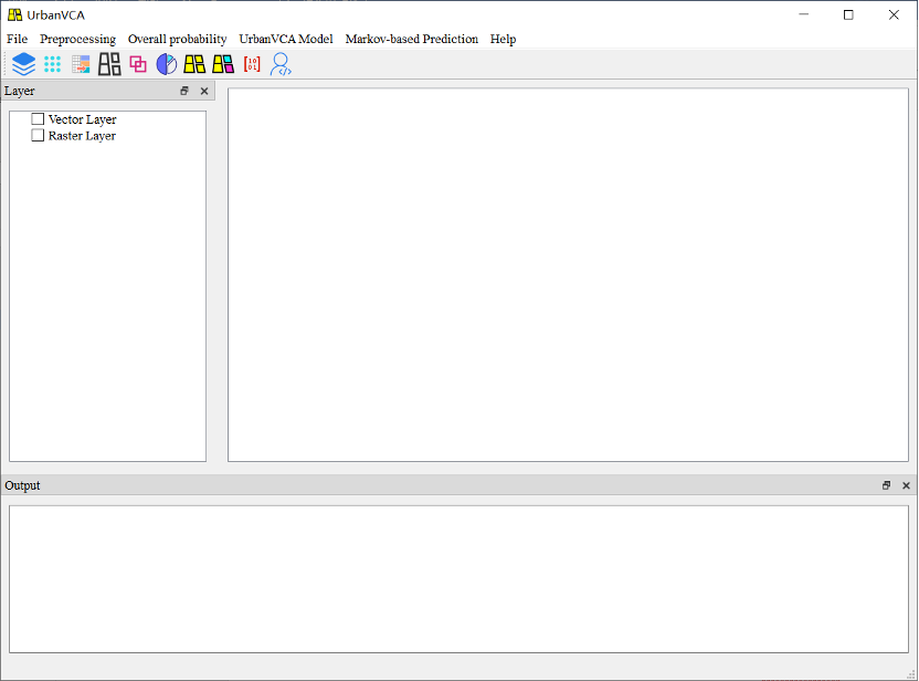
图 1 UrbanVCA主界面
Figure 1 UrbanVCA main interface
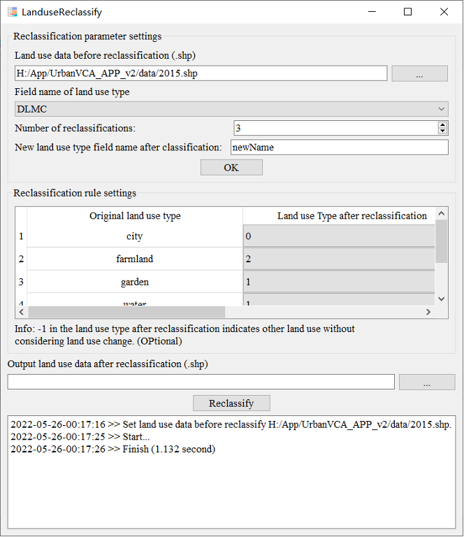
图 2 土地利用重分类界面
Figure 2 Land use reclassification interface
该界面可用于对土地利用类型进行重分类并数字编码,以便于后续软件操作。
The interface can be used to reclassify and numerically code land use types for subsequent software manipulation.
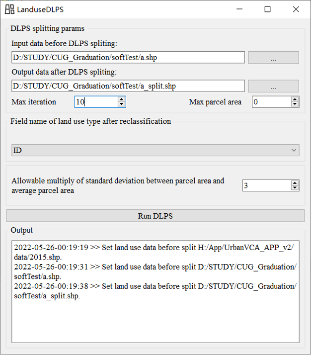
图 3 动态地块分裂界面
Figure 3 Dynamic block splitting interface
该界面优化了原有动态地块分裂算法,修复了部分地块无法分裂的错误,且更新后的动态地块分裂算法效率明显提升。
The interface optimizes the original dynamic block splitting algorithm, fixes the bug that some blocks cannot be split, and the updated dynamic block splitting algorithm is significantly more efficient.
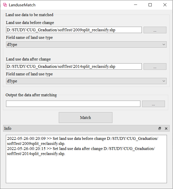
图 4 地块匹配界面
Figure 4 Parcel matching interface
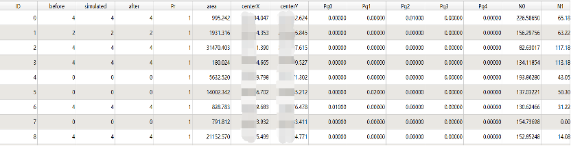
该界面实现了对矢量地块土地利用变化前后用地类型的自动匹配,且结果数据属性列表将自动生成字段:ID、before、simulated、after、Pr、area、centerX、centerY、Pg0、Pg1…Pgn、N0、N1…Nn。其分别表示:地块ID序列号、土地利用变化前的地块用地类型、土地利用模拟的变化后地块用地类型、土地利用变化后的地块用地类型、限制因子、地块面积、地块质心坐标X、地块质心坐标Y、地块发展为第0种用地类型的总体发展概率、地块发展为第1种用地类型的总体发展概率…地块发展为第n种用地类型的总体发展概率、地块受第0种用地类型的邻域效应、地块受第1种用地类型的邻域效应…地块受第n种用地类型的邻域效应。数据自动生成的属性列表,如下所示:
This interface realizes the automatic matching of land use types before and after the land use change of vector parcels, and the resulting data attribute list will automatically generate fields: ID, before, simulated, after, Pr, area, centerX, centerY, Pg0, Pg1...Pgn, N0, N1...Nn. They respectively represent: the serial number of the parcel ID, the type of the parcel before the land use change, the type of the parcel after the change of the land use simulation, the type of the parcel after the change of the land use, the restriction factor, the area of the parcel, the type of the parcel The coordinates of the center of parcel X, the coordinates of the center of mass of the parcel Y, the overall development probability of the parcel developing into the 0th land use type, the overall development probability of the parcel developing into the first land use type... The overall development probability of the parcel developing into the nth land use type Probability, parcels are affected by the neighborhood effect of the 0th land use type, parcels are affected by the neighborhood effect of the 1st land use type... parcels are affected by the neighborhood effect of the nth land use type. The list of properties automatically generated by the data is as follows:
(图片来源于QGIS)
(The figure comes from QGIS)
后续所有操作都将基于上述字段,用户可随时对各参数进行查看与修改。
All subsequent operations will be based on the above fields, and users can view and modify each parameter at any time.
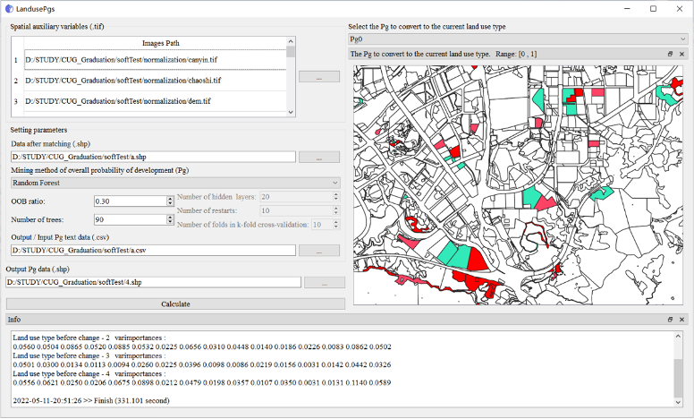
图 5 总体发展概率计算界面
Figure 5 Calculation interface of overall development probability
该模块可基于随机森林、神经网络与逻辑回归等机器学习算法,挖掘并动态显示地块级别的总体发展概率,结果文件的属性列表也将自动生成总体发展概率字段值,以便于用户查看与修改。用户也可外部导入Pg文件或直接基于GIS软件对总体发展概率值进行修改。此外,用户可在日志状态栏中查看各个模型训练过程的相关参数。
Based on machine learning algorithms such as random forest, neural network and logistic regression, this module can mine and dynamically display the overall development probability at the plot level. The attribute list of the result file will also automatically generate the overall development probability field value, which is convenient for users to view and modify . Users can also import Pg files externally or modify the overall development probability value directly based on GIS software. In addition, users can view the relevant parameters of each model training process in the log status bar.
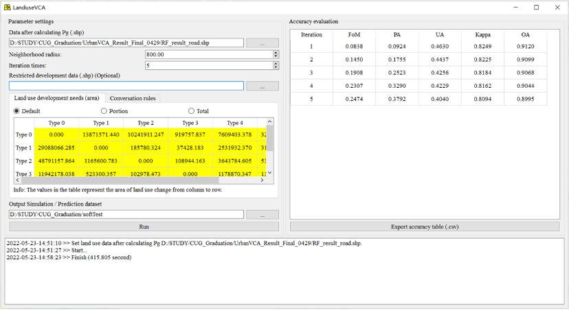
图 6 UrbanVCA模拟界面
Figure 6 UrbanVCA simulation interface
该模块可设置邻域效应半径、模拟迭代次数、限制发展区域、转换规则设置,同时新增了各类土地利用类型转化面积的设置功能,以及FoM、PA、UA、Kappa、OA等多种精度评价指标。
This module can set the radius of neighborhood effect, the number of simulation iterations, the restricted development area, and the setting of conversion rules. At the same time, the function of setting the conversion area of various land use types has been added, and various precisions such as FoM, PA, UA, Kappa, and OA are added. evaluation indicators.
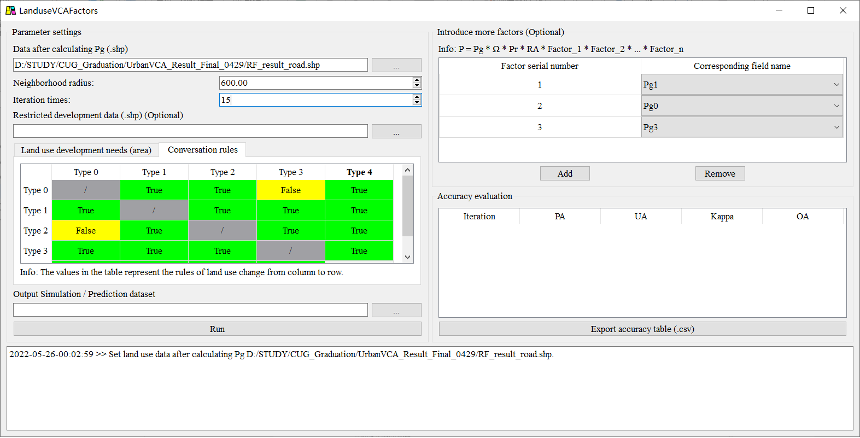
图 7 附加条件的UrbanVCA模拟界面
Figure 7 UrbanVCA simulation interface with additional conditions
考虑到当前研究涉及的矢量元胞自动机模型构建方式越来越多,许多研究在原有元胞自动机模型基础上考虑了多个附加因子:
其中,Pg表示总体发展概率,Pr表示限制因子,Ω表示邻域效应,RA表示随机因子,Factor_x表示第X个附加因子。
因此,为了便于研究人员展开相关研究,本团队在原有模型基础上设计并开发了附加因子的UrbanVCA模型。
Considering that the current research involves more and more ways of constructing vector cellular automata models, many studies have considered multiple additional factors on the basis of the original cellular automata models:
Among them, Pg is the overall development probability, Pr is the limiting factor, Ω is the neighborhood effect, RA is the random factor, and Factor_x is the Xth additional factor.
Therefore, in order to facilitate researchers to carry out related research, our team designed and developed the UrbanVCA model with additional factors based on the original model.
软硬件系统需求 (Software and hardware system requirements):
内存 >= 4GB (RAM >= 4GB)
硬盘空间 >= 3GB (Hard Disk Space >= 3GB)
Windows 8.1及以上版本 (Windows 8.1/10 or above)
Visual C++ Redistributable 2017
软件下载 (Binary Download)
点此下载软件(software download)
内含软件、测试数据与中英文说明书
It contains software, test data and manuals in both Chinese and English.
点此下载演示视频(demo video download)
*2.1版本修复bug:修复马尔可夫链功能中对地块面积统计未初始化,可能造成的面积统计异常问题。
*Bug fix in version 2.1: Fix an abnormal area count problem that may be caused by the uninitialization of plot area count in Markov chain function.
*2.2版本修复bug:优化附加因子的 UrbanVCA 模型模拟功能。
*Bug fix in version 2.2: Optimizing the UrbanVCA Model Simulation Function for Additional Factors.
*2.3版本修复bug:修复了训练数据读入只能读float32格式数据的问题。
*Bug fix in version 2.2: Fixed the issue where training data can only read float32 format data.
视频教程 (Video Tutorials)
矢量地块级模拟和分析软件集(UrbanVCA和VecLI)教学视频: https://urbancomp.net/archives/urbanvca-vecli-tutorial-video
Urbanvca & Vecli Tutorial Video: https://urbancomp.net/archives/urbanvca-vecli-tutorial-video
Q.E.D.