


ABSTRAT
Researches on the urban development and urban planning have an urgent need for building geographic
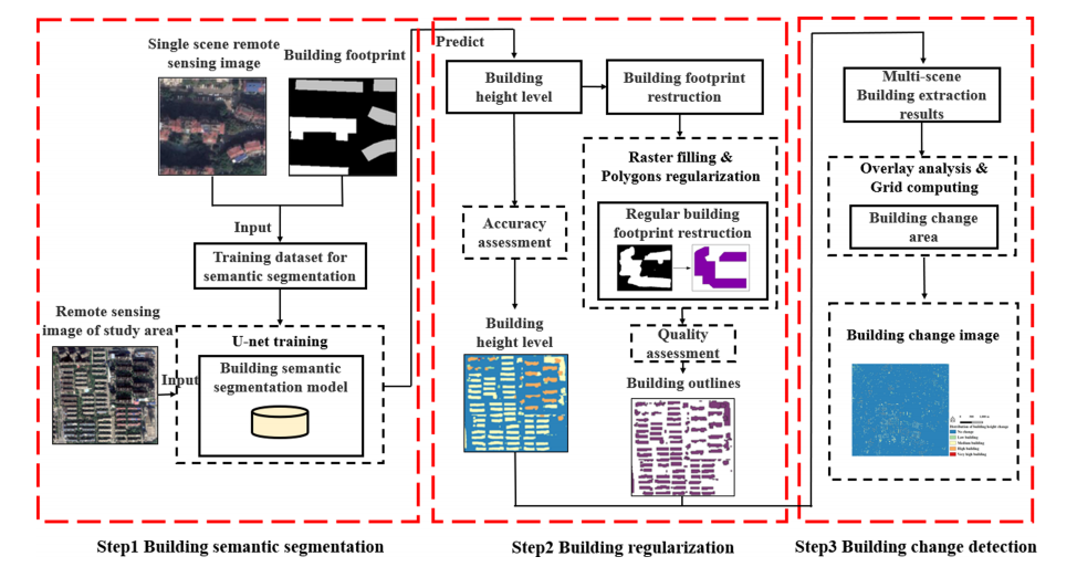
data. Traditional methods of extracting buildings from high-resolution remote sensing images need multi-view images, and have a high cost but a low degree of automation. Thus, these methods are not applied in many fields at large-scale. This study couples U-net and single-view high-resolution remote sensing images to propose a low-cost and simple method for the extraction of the contour and level of the buildings in the remote sensing image. This study adopts the central urban area of Wuhan, Hubei, China as the case study. The results show that the proposed method obtains high accuracies both in identifying building height level (OA = 0.823, Kappa = 0.502) and contour. Compared with the method based on the normalized digital surface model (nDSM), the proposed method obtained a higher overall accuracy of height level extraction increased by 23.4%. The overall quality of building contour extraction is high, and 78.87% of the grids covered by buildings have a building completeness index above 0.4. In addition, we detected and analyzed the changes in buildings in the Nanhu district in the study area based on the proposed method. The results indicated that the height levels of newly added buildings are mainly low and middle levels. The above results have demonstrated the validity of proposed method for extracting buildings contours and level. Moreover, the proposed method can provide scientific supports and reliable help for urban management and renewal.
Q.E.D.