
The inequalities of different dimensions of visible street urban green space provision
Title:The inequalities of different dimensions of visible street urban green space provision: A machine learning approachHighlightsA machine-learning


Title:The inequalities of different dimensions of visible street urban green space provision: A machine learning approachHighlightsA machine-learning
Title:Visible green space predicts emotion: Evidence from social media and street view dataHighlightsAssessed natural outdoor environment-emotion asso
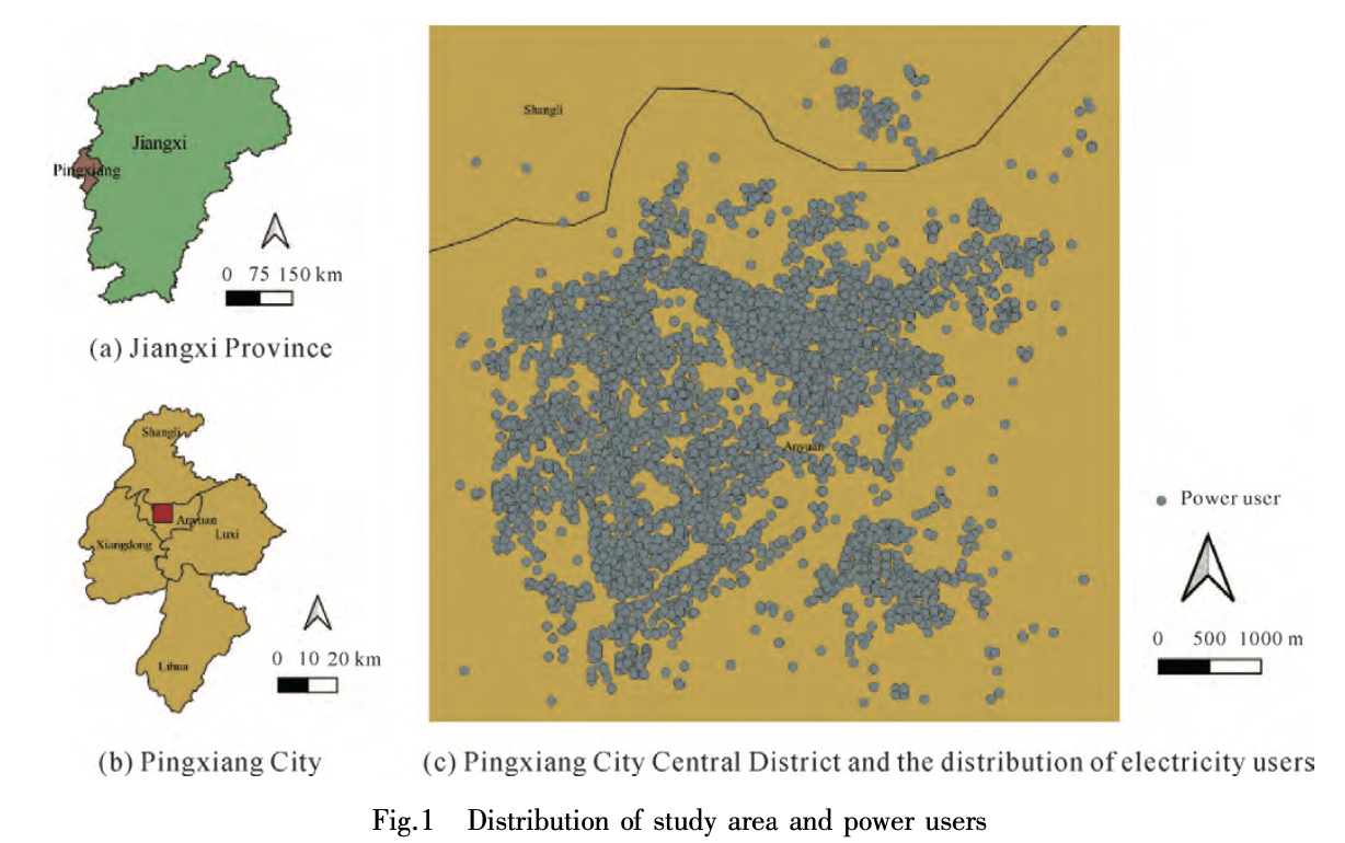
Title:Estimating the spatial variation of electricity consumputionAbstractEffective detection of abnormal electricity users and analysis of the spatia
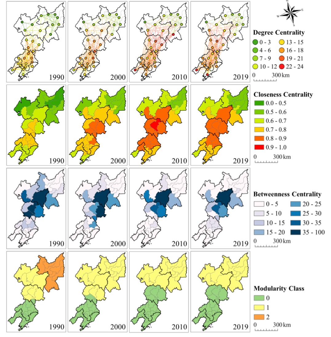
Title:Spatial-Temporal Patterns of Network Structure of Human Settlements Competitiveness in Resource-Based Urban AgglomerationsAbstractResource-based
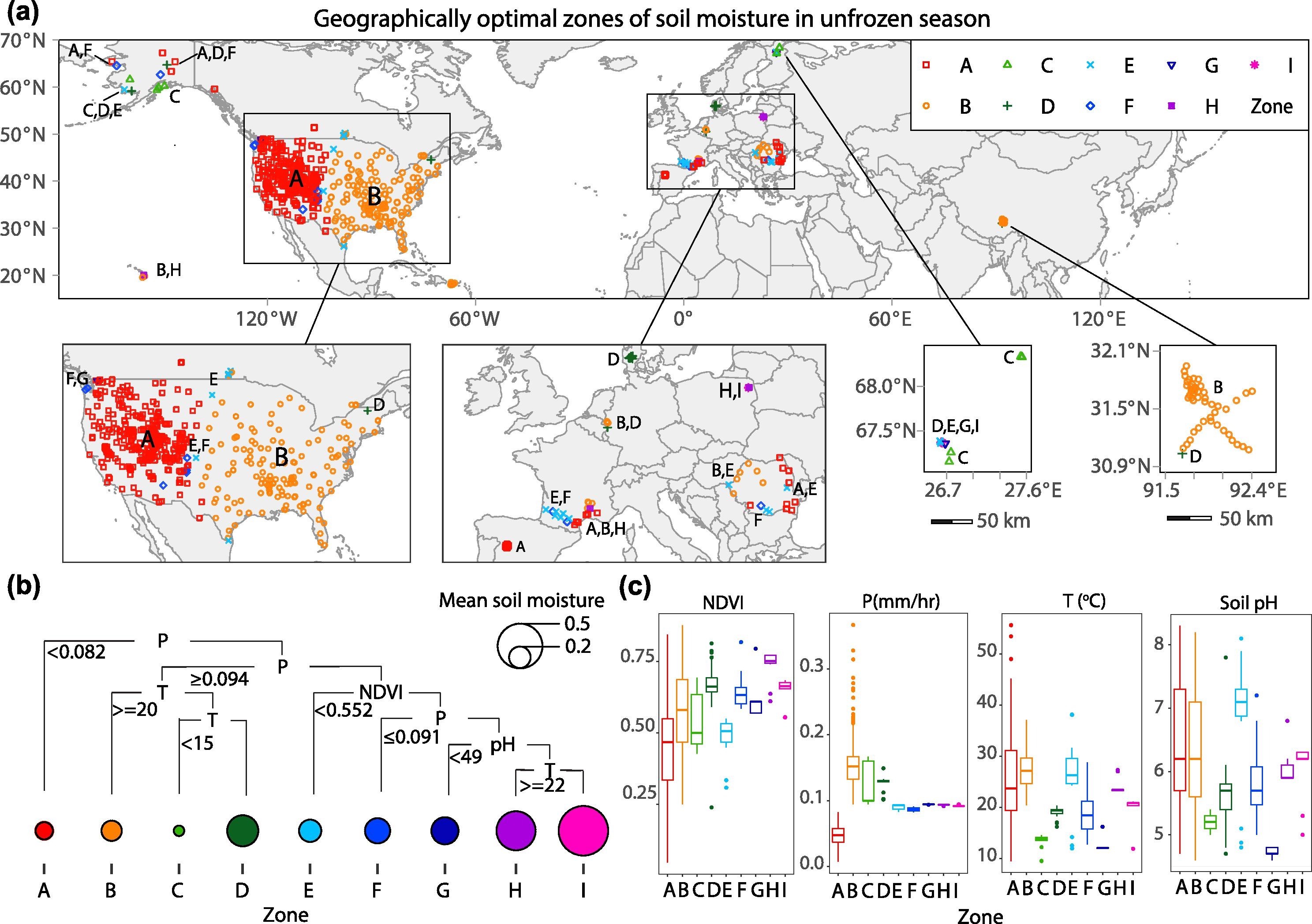
Soil moisture is a fundamental ecological component for climate and hydrological studies. However, the distribution patterns of soil moisture are spatially heterogenous and influenced by multiple environmental factors. The knowledge is still limited in assessing the large-scale spatial heterogeneity of soil moisture in in situ data modelling, in situ network design, spatial down-scaling, and remote sensing-based soil moisture retrieval. Heterogeneity models are effective in characterizing spatial disparities, but they are not capable of examining the maximum regional disparities. To address this bottleneck, the authors of this study developed a geographically optimal zones-based heterogeneity (GOZH) model. By progressively optimizing geographical zones of soil moisture and quantifying the heterogeneity among zones, GOZH may help identify individual and interactive determinants of soil moisture across a large study area. It was applied to identify spatial determinants of in situ soil moisture data collected at 653 monitoring stations in the Northern Hemisphere in unfrozen and frozen seasons from April 2015 to December 2017, with only thawed data considered in both seasons. Correspondingly, a series of variables were derived from Google Earth Engine (GEE) remote sensing data. The results demonstrated the significant regional disparities of soil moisture, and the combinations of determinants are critically different among geographical zones and between unfrozen and frozen seasons. At a global scale, the combinations of determinants can explain about 48% of the spatial pattern of soil moisture. Spatial heterogeneity of soil moisture in frozen seasons is much more complex than that in unfrozen seasons regarding geographical zones and explanatory variables. The variability of soil moisture during unfrozen seasons can be more explainable than that during frozen seasons, which was a convincing evidence for previous studies that soil moisture predictions were mostly performed during unfrozen seasons. Primary variables that determine spatial patterns of soil moisture are changed from climate variables during the unfrozen season to geographical variables during the frozen season. Results show that GOZH model can effectively explore spatial determinants of soil moisture through avoiding the underestimation of individual variables, overestimation of multiple variables, and finely divide zones. The research findings from this study provide an in-depth understanding of the spatial heterogeneity of soil moisture and can be implemented in more effective in situ sampling network design, spatial down-scaling of soil moisture, and accurate inversion of surface parameters from the satellite data of soil moisture.
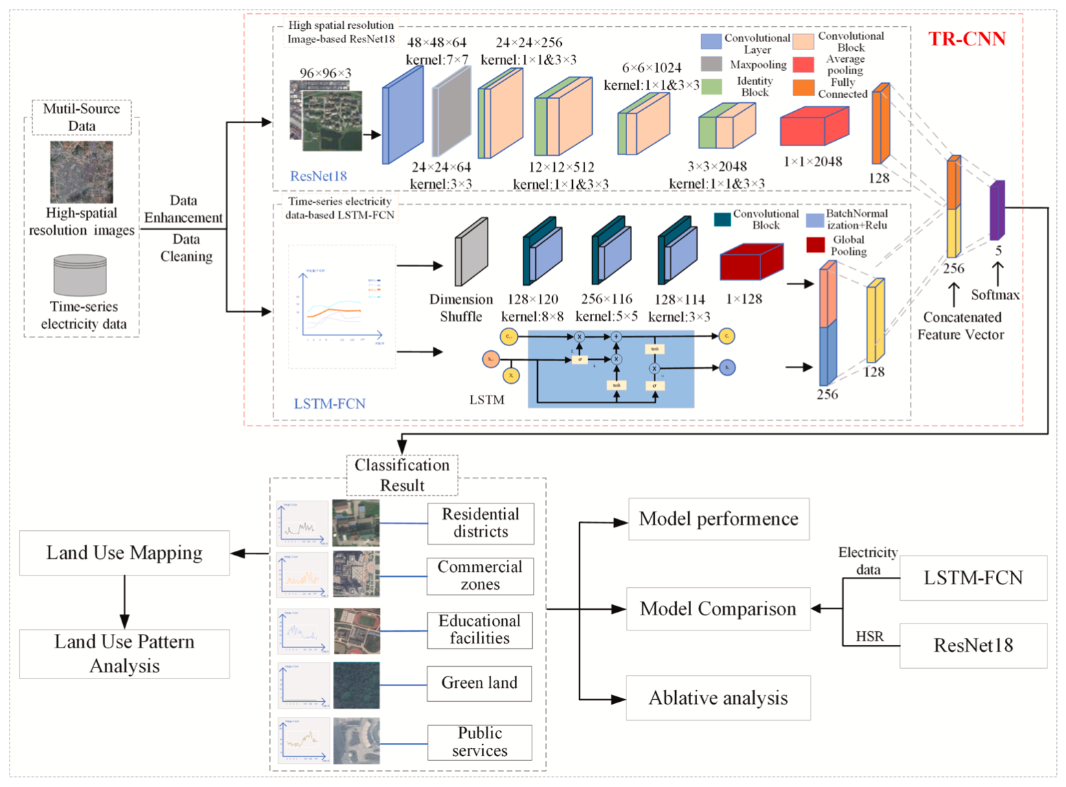
HighlightsA deep learning model (TR-CNN) for land-use classification at fine scale is proposed.TR-CNN can fuse multi-source features from HSR and elec
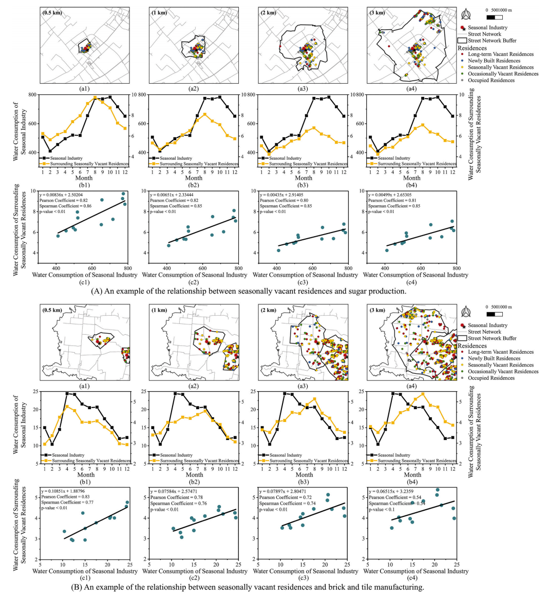
AbstractUnprecedented urbanization in China has directly resulted in residential vacancies, which has seriously stunted sustainable development, a pa
ABSTRATThe spatial structural features and compositional relationships of multivariate geochemicals are influenced by complex geological processes (e.

AbstractEmpirical data are limited to decipher where people live and work in large cities; however, neighborhood information, such as street view imag

AbstractPrevious literature has examined the relationship between the amount of green space and perceived safety in urban areas, but little is known a
UrbanComp
![]()
![]()
![]()